Geographic Information Systems Analysis
Images
There is tremendous need for expanding access to medical imaging to disadvantaged populations around the world. Executing effective and sustainable global health radiology projects to confront this need, however, requires strategic planning and careful resource allocation.
Geographic information systems (GIS) analysis is proving increasingly useful to these efforts by helping to identify the most vulnerable populations in a region and account for the various infrastructure constraints pertinent to radiology outreach.
GIS as a Visualization Tool
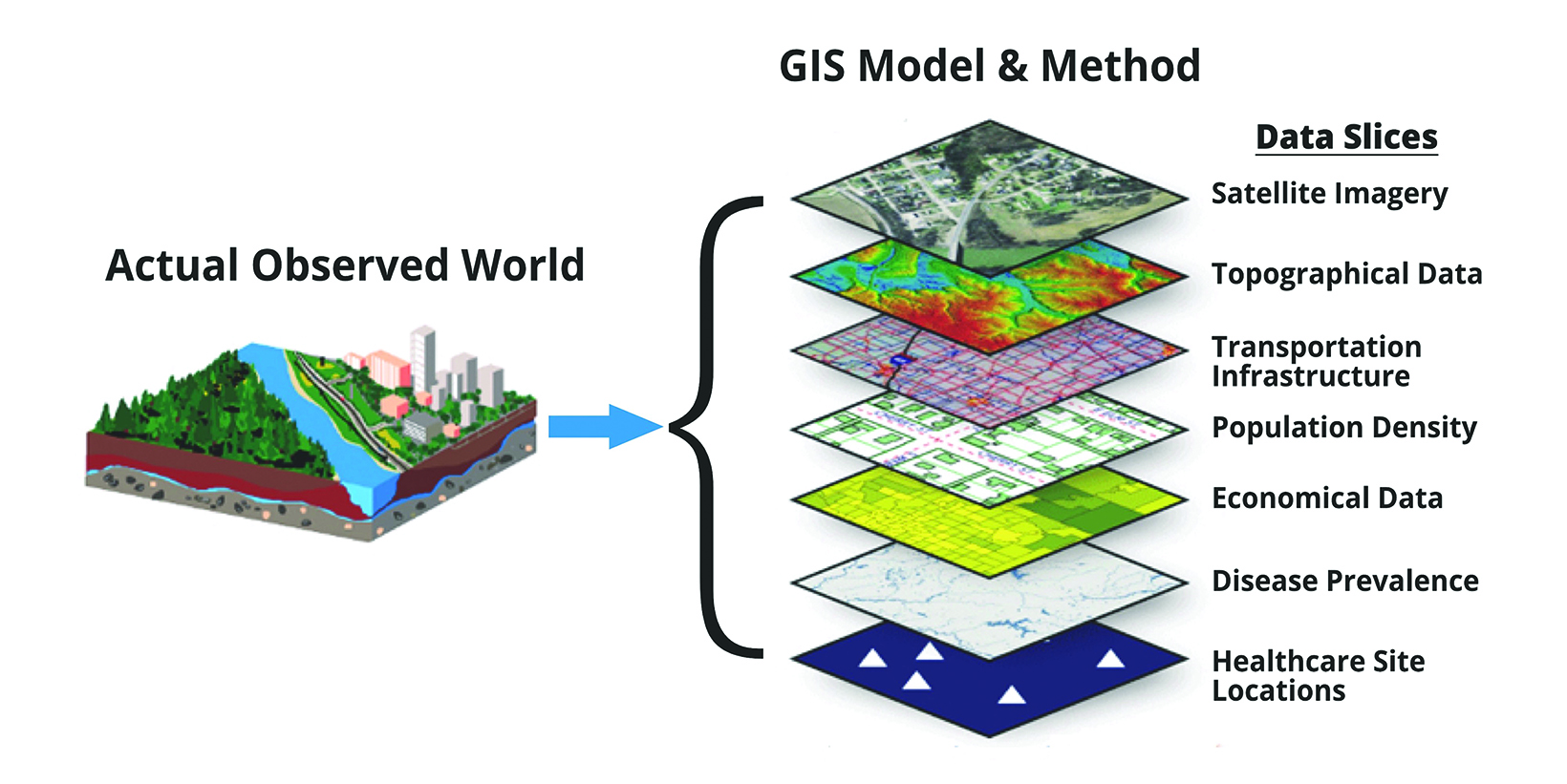
At its most basic level, GIS helps us to organize, understand, and communicate a variety of geographic data and patterns. It offers the advantages of publicly available, satellite-derived databases to create sophisticated maps that incorporate various population and health data, as well as infrastructure and terrain information. Each data set can be considered a “layer” of interest to the user (Figure 1); when several of these layers are stacked atop one another, they create refined maps that drive decisions and assess outcomes.
GIS-produced maps are used throughout our everyday lives to communicate data more effectively. For instance, GIS drive the way we view weather and wind patterns, shipping and flight routes, political party segregations and electoral maps, and even COVID-19 transmission and prevalence—all at local, regional, national, or global levels.
Impact on Global Health Radiology
Planning and implementing a global health radiology project can be complex and daunting. Once a problem is identified for a particular vulnerable population, a possible solution can be proposed. However, a number of additional variables must be considered before a solution can be implemented successfully and sustainably. Take, for instance, hospitals located in a region of a low-resource country with no access to computed tomography (CT) scanners. While one solution may be to provide a hospital in the region with a CT scanner, various infrastructure and staffing variables must be assessed. These questions include: Are there reliable roads for transporting this delicate and heavy medical equipment? Is the local power grid reliable for powering the scanner? What is the availability of staffing—including radiologists, nurses, and technologists? Can the hospital’s laboratory complement imaging findings and assess biopsy samples? Are there suitable referral resources for any imaging or pathologic diagnosis found by the introduced technology? These are all important questions that GIS analysis can help providers to answer.
GIS in Action
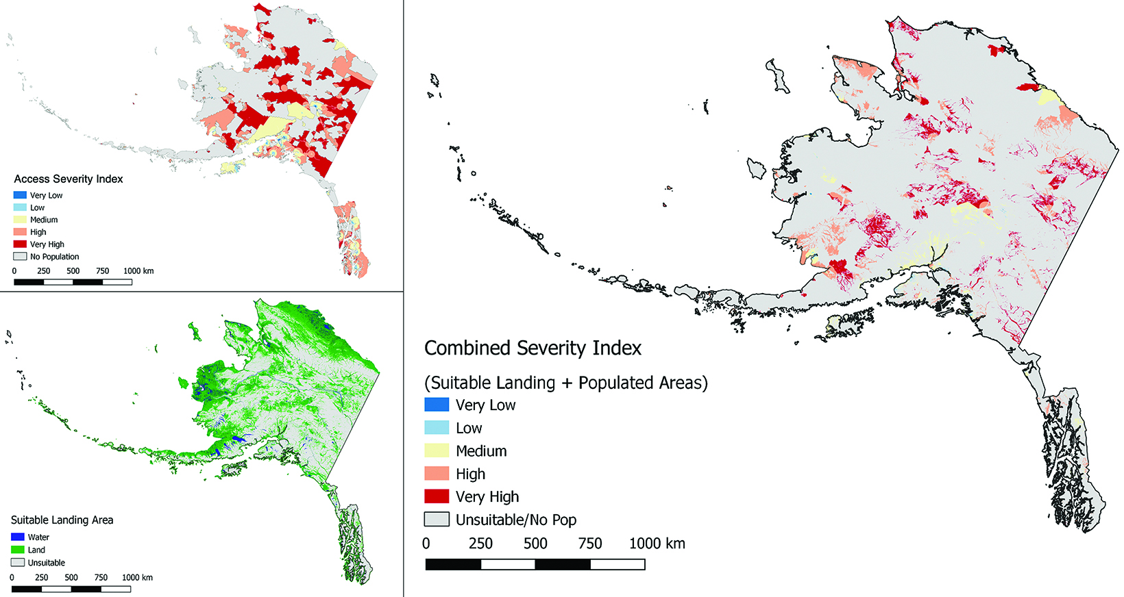
RAD-AID International (Chevy Chase, Maryland) has several practical applications of GIS in various project planning efforts. In Alaska,1 for example, RAD-AID has used GIS to plan mobile health outreach via a newly designed medical hybrid airship capable of carrying heavy, delicate imaging equipment long distances and landing on unprepared surfaces such as grass, dirt, snow, and ice.2 To help identify areas most in need of imaging services, GIS leveraged variables such as population density, percent of uninsured, and life expectancy, as well as distance from roads, clinics, and hospitals and other infrastructure-related variables. Using this multi-variable, multi-weighted approach, RAD-AID was able to create a combined severity index map to identify 22% percent of the state’s population as “high” or “very high” severity.
A second GIS map was created using topographical data to locate acceptable operational zones for the hybrid airship, including bare or low-vegetation land with less than three degrees of slope. This led to the identification of 39% of Alaska’s total land area as safe for takeoff and landing. Together the two maps helped RAD-AID experts determine populations that were most vulnerable and accessible by the airship (Figure 2). Using this analysis enabled the organization to design a suitable base of operations, flight paths, and resource allocations.
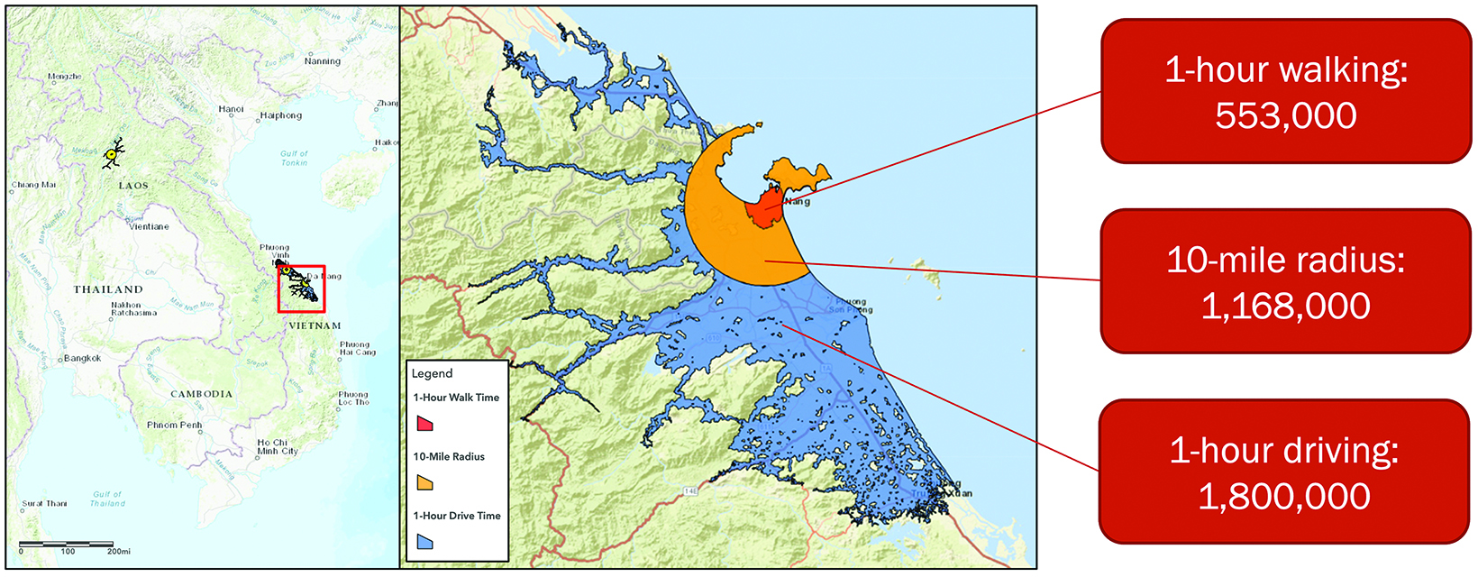
On a larger scale, GIS has been used to analyze RAD-AID’s outreach efforts to better inform its country and operational leaders for project planning.3 One robust analysis looked at 78 individual sites in 32 countries to estimate each location’s catchment population and demographic makeup. Transit time was used to calculate three different constraints: one-hour driving time, one-hour walking time, and a fixed, 10-mile radius (Figure 3). GIS helped to estimate the total population served by all sites within a one-hour drive at 189 million people. The resultant maps can then be manipulated to reveal different population breakdowns. For example, a breast imaging operational leader may wish to identify women aged 40 and older for breast cancer screening outreach; the GIS-produced map would reveal a total population of 24.8 million that fit this description.
Useful in the United States
Besides its increased use in radiology outreach planning, GIS can likely be useful to radiologists in the US. For example, starting a mobile health clinic can be a daunting task. However, GIS can help locate and highlight targeted patient populations and then help create an efficient driving route to multiple sites. Deciding where to place new outpatient imaging facilities can be equally difficult, but GIS can produce a map showing practices already present in a region along with their respective catchment populations, thus highlighting areas of greatest need or identifying specific patient populations for a particular imaging modality or procedure (eg, older men for prostate artery embolization).
Conclusion
Geographic information systems analysis is an important, evolving tool for radiologists, especially as it pertains to regional project planning and resource allocation. While this mapping aid is particularly useful for global health radiology, there is also great potential for local implementation as well.
References
- Daniels MJ, Game A, Mollura DJ, England RW. Strategic radiology outreach planning for underserved populations using geographic information systems. J Am Coll Radiol. 2021 Apr;18(4):537-544. doi: 10.1016/j.jacr.2020.08.022. PMID: 33137295.
- England RW, Gage D, Kesselman A, Mollura DJ. To new heights: interventional radiology outreach to underserved regions via aircraft-delivered mobile health units. Cardiovasc Intervent Radiol. 2021 Sep;44(9):1478-1480. doi: 10.1007/s00270-021-02869-3. PMID: 34019110.
- Gage DC, Lugossy AM, Mollura DJ, England RW. Estimating catchment populations of global health radiology outreach using geographic information systems analysis. J Am Coll Radiol. 2022 Jan;19(1 Pt A):76-83. doi: 10.1016/j.jacr.2021.09.024. PMID: 34699775.
References
Citation
RW E.Geographic Information Systems Analysis. Appl Radiol. 2022; (3):33-34.
April 26, 2022